Mexico’s best national parks are not all the same type of place. Some are volcanic highlands, some protect jungle around archaeological sites, and others are marine parks built around reefs, islands, and bays. The strongest choices for a professional travel article are the parks that combine clear identity, real visitor access, protected landscapes, and enough practical information to plan a visit well.
Mexico’s most impressive national parks for nature, scenery, and travel
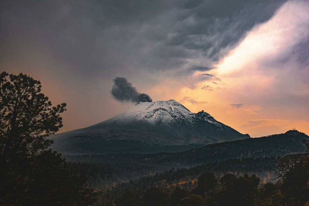
Iztaccíhuatl–Popocatépetl National Park
Iztaccíhuatl–Popocatépetl is one of Mexico’s most important mountain parks because it protects two famous volcanic peaks and a wide belt of high-altitude forest and alpine terrain. This is the place to see cold landscapes, volcanic slopes, open ridgelines, and broad views over central Mexico. It feels wild and elevated in a way that is rare so close to the country’s largest urban region, which is why it stands out from more accessible forest parks.
The park was created in 1935 and covers about 39,819 hectares. The main approaches are through San Pedro Nexapa in the State of Mexico and Santiago Xalitzintla in Puebla. Parking is usually informal or tied to mountain access roads rather than large visitor complexes. Conditions can change quickly because of weather and altitude, and the active nature of Popocatépetl affects the wider area. It is best for hikers, climbers, and travelers prepared for thin air and basic infrastructure.
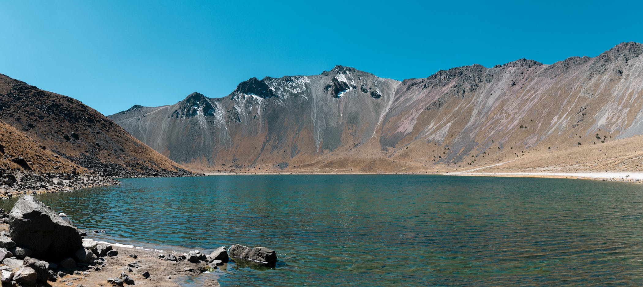
Cañón del Sumidero National Park
Cañón del Sumidero is one of the most dramatic parks in Mexico because the main attraction is immediate and easy to understand: a deep river canyon with steep rock walls, tropical vegetation, viewpoints, and boat routes. It is a park built around vertical scale. From the water, the canyon feels enclosed and massive; from the miradores above, it opens into a broad and sculptural landscape. That double perspective is what makes it more memorable than many other scenic parks.
The park was decreed in 1980. Visitors usually enter either by road from Tuxtla Gutiérrez to the lookout zone or by boat from Chiapa de Corzo. Parking is concentrated near embarkation points and viewpoint areas, so logistics are easier than in remote mountain reserves. It is ideal for scenic travel and photography rather than long trekking. Timing matters because the experience depends on road circulation, boat departures, and weather rather than on an all-day trail network.
Palenque National Park
Palenque is one of the best national parks in Mexico because it combines tropical forest with one of the country’s most important Maya archaeological sites. What makes it special is not only the ruins themselves, but the way they sit inside humid jungle with wildlife, dense vegetation, and a strong sense of place. It feels more alive and atmospheric than a dry open-air archaeological zone, which gives the visit more depth.
The park was created in 1981 and protects around 1,772 hectares. It is accessed from the city of Palenque in Chiapas, and parking is linked to the archaeological and tourism infrastructure around the site. Visitors come for the ruins, forest paths, viewpoints, and wildlife, including monkeys and tropical birds. It is not a park for long backcountry hiking, but it is excellent for travelers who want nature and culture in one destination with relatively straightforward access.
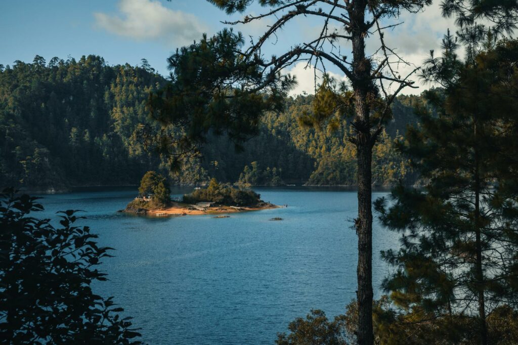
Lagunas de Montebello National Park
Lagunas de Montebello stands out because its appeal comes from variety rather than from one landmark. The park is known for a chain of lakes with changing colors, from light turquoise and green to deeper blue tones, surrounded by forested highland scenery near the Guatemala border. It is one of the most visually distinctive inland parks in Mexico and works especially well for scenic driving, photography, and short stops across multiple viewpoints.
The park was established in 1959. Access is road-based, and visitors typically move through the park by car between different lagoon areas. Parking is usually local and linked to individual lake viewpoints, community-run stops, and service points rather than one central entrance. The park is better for flexible sightseeing than for major trekking mileage. It suits travelers who want a full day of changing scenery, short walks, and a landscape that looks very different from Mexico’s volcanic and coastal parks.
Grutas de Cacahuamilpa National Park
Grutas de Cacahuamilpa is one of the best parks in Mexico for geology and underground scenery. Instead of peaks or coastline, the park protects a major cave system with huge chambers, rock formations, and a sense of scale that surprises even experienced travelers. It is one of those places where the attraction is clear from the start: the cave itself is the destination, and the visit depends on the power of the interior space rather than on surrounding viewpoints.
The park was created in 1936 and is located in the region between Guerrero and Morelos, with Taxco serving as one of the main nearby reference cities. Access is mainly by road, and parking is tied to the cave visitor area. It is suitable for day trips, families, and travelers who want a strong natural landmark without a difficult expedition. The main limitation is that the experience is more structured than in open wilderness parks, but that is also what makes it easy to visit.
Cofre de Perote National Park
Cofre de Perote is one of the best highland parks in Mexico for travelers who want mountain scenery without the heavier symbolism and restrictions of the central volcano parks. Its main landmark is the 4,200-meter Cofre de Perote, which CONANP describes as the sixth-highest mountain in the country. What makes the park attractive is the contrast between forested slopes, open high ground, cold air, and broad views over Veracruz. It is a strong choice for hikers, photographers, and travelers who want a mountain landscape that feels serious but still manageable as a road-based trip.
The park was created in 1937. Official CONANP information identifies Perote as the main nearby locality, around 18 km from the summit, with Puebla’s Hermanos Serdán airport listed as the main airport reference. Access is mainly by road, and parking is usually tied to approach points and mountain service areas rather than to one formal visitor complex. The park works best for day ascents, viewpoints, and cool-season travel. As with other high-altitude parks in Mexico, the main practical limits are weather, thin air, and relatively basic infrastructure rather than heavy entry formalities.
Cumbres de Monterrey National Park
Cumbres de Monterrey is one of the strongest inland parks in northern Mexico because it protects a huge mountain landscape with canyons, dry lower slopes, forested upper areas, and major water-catchment value for the region. CONANP describes it as the largest national park in Mexico in its category and highlights the contrast between arid lower zones and forest in the higher parts. The park is especially known for La Huasteca Canyon and the forest zone around Ciénega de González, which gives it a broader identity than a single-viewpoint destination.
The park was first decreed in 1939. It is used year-round, and official state listings note daily access and an entry fee framework through CONANP. In practical terms, the park is approached from the Monterrey metropolitan area, especially by road corridors leading toward the Sierra Madre sectors, so access is dispersed rather than concentrated at one gate. Parking depends on the zone visited, with roadside and local access points more common than a centralized national-park layout. It is best for canyon scenery, mountain driving, hiking, and short nature escapes from the city rather than for one single classic trail system.
Cabo Pulmo National Park
Cabo Pulmo is one of the best national parks in Mexico because it protects one of the most important coral reef systems in the Gulf of California and is one of the clearest examples of marine recovery in the country. This is not a park defined by long inland routes or viewpoints. Its value comes from the reef, marine life, clear water, and the feeling that the landscape continues below the surface. It is best known for snorkeling, diving, and wildlife-focused coastal travel rather than for classic land hiking.
Official CONANP information says access is by road from San José del Cabo, about 98.1 km away, or from La Paz, about 167 km away, and that transport is basically by private or rented car. The park is open daily from 8:00 a.m. to 6:00 p.m. Mobility inside the protected area is listed as walking, which reflects the fact that the road approach ends in a small coastal settlement and activities are organized locally from there. Parking is limited and local rather than large-scale, so this is a place where access feels small and controlled. Rules matter more here than in a normal beach stop because reef use is part of the conservation logic of the park.
Bahía de Loreto National Park
Bahía de Loreto is one of the most complete marine parks in Mexico because it combines desert coast, islands, protected waters, and regular opportunities to see marine mammals. CONANP describes it as one of the most spectacular bays in the Gulf of California, and that is exactly why it works so well in a travel article: it has both scenic scale and wildlife value. The park is characterized by island views, boat-based exploration, clear water, and a strong contrast between arid Baja California landscapes and rich marine life.
The park was created in 1996. Loreto itself is the key practical gateway, and CONANP explicitly identifies the city of Loreto as bordering the park. Access is therefore much easier than in many marine reserves: visitors arrive in Loreto by road or air, then continue by marina services, tours, or private boat arrangements. Parking is urban or marina-based rather than internal to the park. This is an important distinction: the “entrance” is really the town and waterfront infrastructure, not a classic land-park gate. It is ideal for travelers who want sea excursions, island scenery, and wildlife viewing without complicated remoteness.
Arrecifes de Cozumel National Park
Arrecifes de Cozumel is one of Mexico’s best-known reef parks and one of the easiest marine parks to explain geographically. CONANP states that it includes the beaches and marine area from kilometer 6 of the South Coastal Highway to Punta Chiqueros on the eastern side of Cozumel. That gives the park a very clear structure: it is tied to the island’s coastal road and reef zone rather than to one enclosed terrestrial landscape. It is best for diving, snorkeling, reef viewing, and clear-water coastal travel.
Access is straightforward by Mexican island standards. Visitors can reach Cozumel by ferry from Playa del Carmen, by cargo ferry with a vehicle from the mainland, or by air to the island, then continue south by taxi or car along Rafael E. Melgar Avenue and the coastal road. Official CONANP state listings show daily operating hours from 6:00 a.m. to 10:00 p.m. Parking is scattered along coastal access points and service areas rather than centralized. The main practical point is that this is a marine-use park: road access is easy, but the core experience depends on reef conditions, operators, and protected-area rules rather than on inland trails.